Many of the wetlands and jungles of Mexico’s state of Chiapas are designated protected areas for a great variety of flora and fauna native to Mexico and Central America. These regions, rife with archaeological treasures and impressive natural landscapes and resources, offer unparalleled opportunities for responsible adventure and eco-touristic activities.
Agua Azul Biosphere Reserve
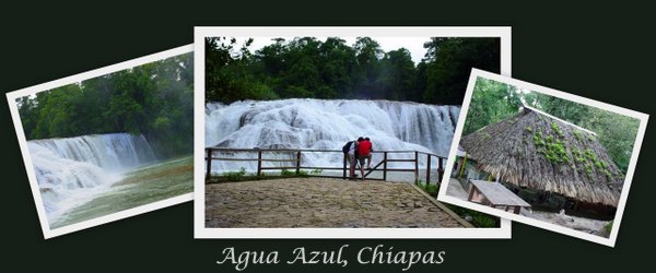
The Agua Azul (Blue Water) Biosphere Reserve and waterfalls on the Shumulhá River, near its confluence with the Tulija River, are located fifty kilometers from Palenque along Highway 199. The raging Agua Azul cataracts are formed by the rapid descent of the waters: they drop about 1,000 meters in a distance of only two kilometers.
At Agua Clara, an ecotourism project developed by the indigenous farmers of the area, the river forms a wide, placid natural pool of crystalline waters perfect for bathing. The river, lined with jungle vegetation, is also excellent for kayaking, and hikers, climbers, and horseback riders can enjoy nature walks and fabulous views from nearby hilltops.
El Triunfo Biosphere Reserve
Located in the Sierra Madre de Chiapas between La Angostura (Presa Belisario Dominguez) and the Pacific lowlands, El Triunfo camp can be accessed most easily via the town of Angel Albino Corzo, taking a dirt road toward Finca Prusia to access the reserve. The altitude in the reserve varies from 450 meters on the Pacific side to 2,750 meters toward Pico el Loro, making for great diversity in the flora, fauna, terrain, and climatic conditions. Here, many species in danger of extinction can be found, such as the quetzal, tapir, and ocelot, as well as bromeliads, mosses, orchids and other plants of tropical, sub-tropical, and pine forests.
Huehuetan and Cantón el Cairo
Huehuetan is located about one-half hour from Tapacula, bordering on Guatemala. It is a favored spot for rafting the rapids and white water along the Cuilco River
La Encrucijada Biosphere Reserve–Las Palmas
Lagoons and jungle wetlands are located on the Pacific coast near Acapetahua. Boats can be hired at the dock at Las Garzas for nature and birdwatching tours. The area hosts over 300 varieties of colorful resident and migratory birds in its dense mangroves.Also represented in this area are multiple species of reptiles, such as crocodiles and marine turtles, and mammals including the ocelot, jaguar, white-tailed deer, and spider monkey. Basic lodging is available at La Concepción Camp from November through May.
Las Guacamayas
Located 252 kilometers from Palenque on a largely paved route near Reforma Agraria, this jungle region full of monkeys, toucans, white-tailed deer, and other wildlife is the special preserve of the Red Parrot. Take a boat tour of the Lacantún River and see the confluence at Paso del Diablo (Devil’s Pass) of two rivers–one an intense blue, the other clear green–that form parallel paths in the same riverbed without mixing their colors. Cabins and dining facilities are available.
Misol-Ha Falls
Eighteen kilometers from the Palenque ruins toward San Cristóbal de las Casas are spectacular thirty-meter high falls stretching across a twenty-meter wide precipice.The large, rounded pool below the falls is deep and refreshingly swimmable. Nearby is a explorable grotto with another small waterfall inside. Cabins and restaurant are available.
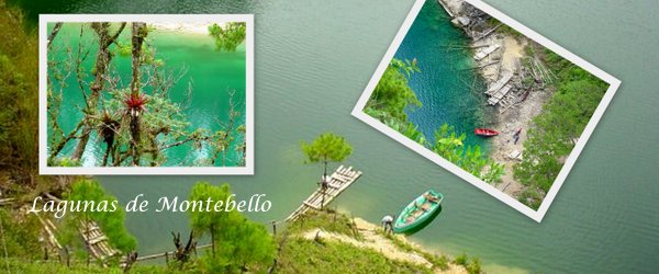
Montebello Lagoons
Located along the Mexico-Guatemala border about two and one-half hours from San Cristóbal de las Casas and one hour from Comitán, the Montebello Lagoons are a conglomeration of more than fifty small,clear, blue-green lakes in an area of only eight square kilometers surrounded by jungle foliage. Their depths vary from some 10 to 120 meters.The most accessible lagoons are Esmeralda, Ensueño, Agua Tinta, Encantada, and Bosque Azul, which are reachable via paved roads.
Montes Azules Biosphere Reserve, Laguna Miramar, and the Lacantun Biosphere Reserve
Located in the far south-east of the State of Chiapas, in the midst of the Lacandon jungle, the Montes Azules Reserve encompasses several archaeological zones, including Bonampak and Yaxchilan, as well as the large and crystalline Lake Miramar on its western edge, on whose islands are the ruins of a Lacandon ceremonial center. Here are found Mexico’s tallest trees, reaching to ninety meters in height, and densest stands of mahogany hardwoods. The lake area of the reserve is accessible via small plane or dirt road from Ocosingo. The Bonampak region is accessible along the border highway from Palenque.
Near Ocosingo, bordering Montes Azules, the wetlands and jungles of the Lacantun Biosphere Reserve harbor over 60 percent of Mexico’s land species, among which are many endangered species such as spider monkeys, white turtles, jaguars, woolly tlacuaches, river otters, ocelots, and toucans.
Selva El Ocote Biosphere Reserve
Near the Veracruz and Oaxaca borders of the State of Chiapas, touching on Presa Netzahualcoyotal lake, is the “El Ocote” reserve, accessible out of Tuxtla Gutierrez and the town of Oxozocoautla. The region was original settled by the Zoque Indians, and several archaeological ruins are located in the area.The forest is home to a variety of hardwoods including mahogany and cedar, and wildlife such as jaguar, puma, spider monkeys, howler monkeys, flying squirrels, and tapirs. Two camps are available on the reserve: Rabasa is located forty kilometers from Ocozocuautla along the road to Apic-pac; El Encajonado is fifty-five kilometers from Ocozocuautla and accessible by a two-hour boat ride along the lake.
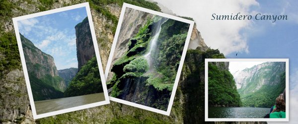
Sumidero Canyon
Just ten kilometers north of Tuxla Gutierrez, Cañon del Sumidero is one of the prime natural attractions of the state. The canyon measures thirteen kilometers in length with cliffsides more than one thousand meters high, offering breathtaking views of the surroundings.
The canyon walls are hung by lush vegetation; water birds abound and monkeys and crocodiles are to be seen along the banks. Boat tours on the Grijalva River and canyon bottom are available from the docks at Tuxtla Gutierrez and Chiapa de Corzo, which was declared a Mexican historical monument zone by the Instituto Nacional de Antropología e História (INAH) in the year 2000. Public transport is available for tours out of Tuxtla Gutierrez, taking you to the Miradores (lookouts) above this impressive canyon for a birds-eye view of the chasm.
Tacana Volcano and Parrot’s Peak
With a height of 4,093 meters, the Tacana volcano, located on the Mexico-Guatemala border along Highway 38, is the highest peak in Chiapas. Great views of the volcano are to be had from the small town of Unión Juárez in the surrounding coffee growing region of the state.Guides are available for mountain climbing expeditions; cabins are available at Papales, halfway up the mountainside. Near the town of Santo Domingo is Pico de Loro, or Parrot´s Peak. The top of the peak is accessible via a dirt road and a walk of about half a kilometer.
- More Chiapas information from http://www.visitmexico.com/en/VisitMexico30/Buscador?q=chiapas
- http://mundomaya.travel/en/naturaleza/espacios-naturales/item/reserva-de-la-biosfera-montes-azules.html
- Nature Conservancy: Mexico http://www.nature.org/ourinitiatives/regions/northamerica/mexico/
- Las Guacamayas camp, http://www.lasguacamayas.mx/