Reading and summarizing the 1824 journal of travels made by a detachment of men sent by the Real del Monte Mining Company from the gulf coast of Mexico into the highlands, I was reminded of the beauties of the countryside in one of Mexico’s unspoiled regions, the Huasteca. The mining detachment traveled through much of that territory, and the descriptions of the rivers, mountains, and lush vegetation showed me that those beauties were as impressive to those men on their arduous trek as they were to us on our more recent visits.
The Huasteca is a geographical area of Mexico that encompasses parts of the states of Tamaulipas, San Luis Potosí, Querétaro, Hidalgo, and the northern tips of Veracruz and Puebla, extending even into Guanajuato. Originally, it comprised the territory over which the Huastec Indians held sway at the peak of their civilization.
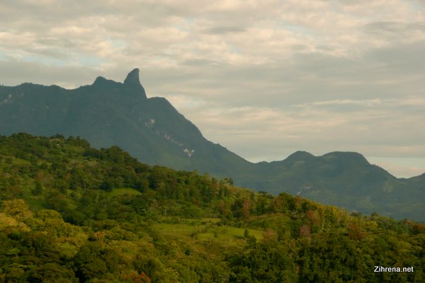
On our travels through Mexico, we’ve often touched upon the edges of the Huasteca. On two occasions, though, we’ve entered deep into its heartland and spent days exploring the rich land that lies between the Sierra Madre Oriental and the Gulf of Mexico, particularly the region where southern Tamaulipas borders the states of San Luis Potosi and Veracruz.
The landscapes are beautiful and the tranquility and simplicity of the area are enchanting. We have traveled it only in the rainy, summer season but have been told that the countryside is as lush and green during the drier winter season because of the presence of so much ground water and the humidity that pushes up against the sierras from the gulf coast.
Truly, the water seems to spring straight out of the ground, and both native vegetation and cultivated crops grow with wild exuberance. Even the fence posts grow! Roadside stands offer varied and colorful produce that include chiles, nuts, and fresh fruits, as well as dried and preserved products. Sugar cane is cultivated extensively (apparently much of Mexico’s piloncillo, or raw cone sugar, is produced here), and coffee comes from the higher, cooler elevations.
Because the Huasteca is riddled with rivers and waterfalls, canyons and gorges, it has become a favorite destination for eco-tourism and extreme sports. It is a nature enthusiast’s paradise.

Within the confines of the Huasteca, near Aquismón, is one of the world’s largest and deepest sinkholes, known as the Sótano de las Golondrinas, or Cave of the Swallows. Every morning, clouds of swifts and parrots (the cave was misnamed) emerge from its maw into the brightening sky. The cave is a favorite spot for vertical cavers and base jumpers.
There are cascades and waterfalls, mineral hot springs, and stretches of water ideal for rafting. There are countless birds to watch, butterflies and insects to identify, and varieties of tropical flowers and vegetation to encounter. There are crags and mountains to scale and archaeological ruins and colonial era missions to explore.
In the coffee-growing hills of Xilitla, just outside of town at Las Pozas, is one of our favorite destinations: the Englishman’s castle or enchanted garden of Edward James. Edward James was an eccentric English poet and avid supporter of the surrealist movement in Mexico who became enamored of the Huasteca and lived there from 1949 until his death in 1984. There’s much more to his story, but I’ll go into that on another occasion.
There are no superhighways cutting through the Huasteca–not yet, anyway. There is one main artery that leads in from the capital of San Luis Potosi via Rio Verde, and another relatively main road that leads south from Ciudad Victoria, Tamaulipas, but the roads in most of the Huasteca region are small, sometimes narrow and winding, and not heavily transited.
We’ve not traveled the roads through the rugged mountain country that lead southward into Central Mexico, but we have been told they are still winding and painfully slow, apt only for travelers willing to take their time and meander–literally–through the mountains at only 30 or 40 kilometers an hour–if that. Many of the old missions are in that area, and I’d truly like to take a trip inland, perhaps from Tamasunchale, along the mission route, following the general direction taken by the men described in the journal from New York to Real del Monte via Tampico, but it would have to be when we have plenty of time to spare.
Historically and ethnically, the La Huasteca region is defined by the area dominated by the Huastecs at their height. The actual extension of the region is somewhat disputed as well as how it should be sub-divided. Geographically it has been defined as from the Sierra Madre Oriental to the Gulf of Mexico with the Sierra de Tamaulipas as the north border and the Cazones River as the south. It extends over the south of Tamaulipas, the southeast of San Luis Potosí, the northeast of Querétaro and Hidalgo and the extreme north of Veracruz and Puebla and a very small portion of Guanajuato over an area of about 32,000km2.
Wikipedia contributors, “La Huasteca,” Wikipedia, The Free Encyclopedia, http://en.wikipedia.org/w/index.php?title=La_Huasteca&oldid=599075125 (accessed May 17, 2014).
Below is a selection of photographs of the Huasteca Potosina (the portion of the Huasteca that lies within the state of San Luis Potosi). In subsequent posts, I’ll detail some of the specific sights of the area we particularly enjoyed: Xilitla and Las Pozas, with its sculptural architecture designed by Edward James; a tour of some of the waterfalls of the Huasteca; and the hotel and hot springs at Taninul resort near Ciudad Valles, which is one of our favorite stops on this route.
More information:
- Touring Sierra Gorda and Huasteca from SundayMorningRides
- La Huasteca Directory
- Extreme sports at Huasteca Potosina from VisitMexico


